


本文基于postgresql13 & postgis3.1.4,工具使用QGIS3.2
01
—
导入路网数据到数据库中
首先导入黑龙江省的高速路网,我使用的是shp格示的矢量数据,直接拖到QGIS中即可,通过postgis自带的导入工具也可以,为了后续查看方便就直接用QGIS了。
之后把数据导入postgresql数据库中:

之后新建连接

点击导入图层或文件,之后选择前面的shp路网文件导入
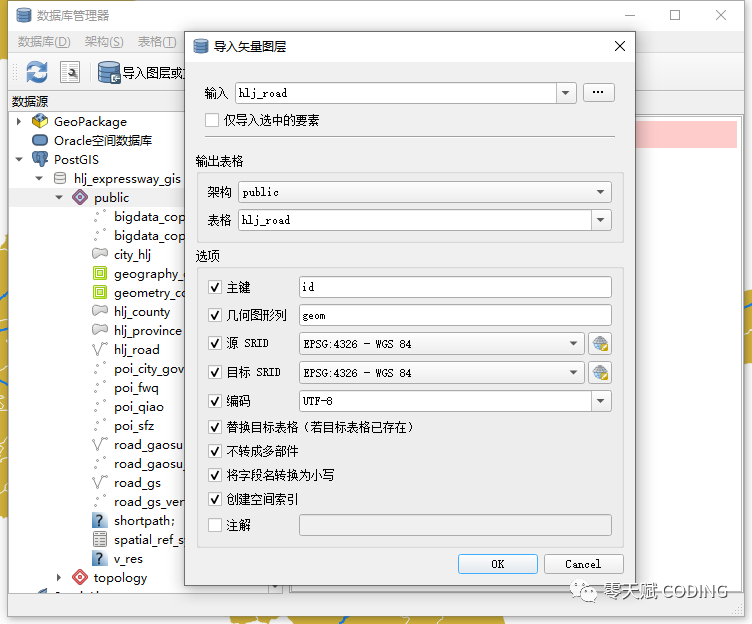
之后在图层中加载导入到postgresql中的表文件,加载到qgis中展示。
02
—
生成拓扑与存储过程
打开pgAdmin客户端,运行以下脚本
--添加起点idALTER TABLE road_gaosu ADD COLUMN source integer;--添加终点idALTER TABLE road_gaosu ADD COLUMN target integer;--添加道路权重值ALTER TABLE road_gaosu ADD COLUMN length double precision;ALTER TABLE road_gaosu ADD COLUMN cost double precision;ALTER TABLE road_gaosu ADD COLUMN reverse_cost double precision;--创建拓扑SELECT pgr_createTopology('road_gaosu',0.00001,'geom','gid','source','target');--为source和target字段创建索引CREATE INDEX source_idx ON road_gaosu("source");CREATE INDEX target_idx ON road_gaosu("target");--计算每一段路的长度update road_gaosu set length =st_length(geom);update road_gaosu set cost = st_length(geom);UPDATE road_gaosu SET reverse_cost = st_length(geom);
source,target,是为每一段路生成的首,尾点的序号,0.00001为容差,即当两段路距离过近时,source,target会被视为相同,被当成一段路来算,所过这个值不要设得过大。
之后新建一个存储过程
CREATE OR REPLACE FUNCTION _myshortpath(tbl character varying,startx double precision,starty double precision,endx double precision,endy double precision)RETURNS geometry AS$BODY$declarev_startLine geometry;--离起点最近的线v_endLine geometry;--离终点最近的线v_startTarget integer;--距离起点最近线的终点v_startSource integer;v_endSource integer;--距离终点最近线的起点v_endTarget integer;v_statpoint geometry;--在v_startLine上距离起点最近的点v_endpoint geometry;--在v_endLine上距离终点最近的点v_res geometry;--最短路径分析结果v_res_a geometry;v_res_b geometry;v_res_c geometry;v_res_d geometry;v_perStart float;--v_statpoint在v_res上的百分比v_perEnd float;--v_endpoint在v_res上的百分比v_shPath_se geometry;--开始到结束v_shPath_es geometry;--结束到开始v_shPath geometry;--最终结果tempnode float;begin--查询离起点最近的线--4326坐标系--找起点15米范围内的最近线execute 'select geom, source, target from ' ||tbl||' where ST_DWithin(geom,ST_Geometryfromtext(''point('||startx ||' ' || starty||')'',4326),15)order by ST_Distance(geom,ST_GeometryFromText(''point('|| startx ||' '|| starty ||')'',4326)) limit 1'into v_startLine, v_startSource ,v_startTarget;--查询离终点最近的线--找终点15米范围内的最近线execute 'select geom, source, target from ' ||tbl||' where ST_DWithin(geom,ST_Geometryfromtext(''point('|| endx || ' ' || endy ||')'',4326),15)order by ST_Distance(geom,ST_GeometryFromText(''point('|| endx ||' ' || endy ||')'',4326)) limit 1'into v_endLine, v_endSource,v_endTarget;--如果没找到最近的线,就返回nullif (v_startLine is null) or (v_endLine is null) thenreturn null;end if ;raise notice 'v_startLine 1-%',geometrytype(st_linemerge(v_startLine));raise notice 'v_endLine 1-%',geometrytype(v_endLine);raise notice 'v_startSource 1-%',v_startSource;raise notice 'v_endSource 1-%',(v_endSource);raise notice 'v_startTarget 1-%',(v_startTarget);raise notice 'v_endTarget 1-%',(v_endTarget);select ST_ClosestPoint(v_startLine, ST_Geometryfromtext('point('|| startx ||' ' || starty ||')',4326)) into v_statpoint;select ST_ClosestPoint(v_endLine, ST_GeometryFromText('point('|| endx ||' ' || endy ||')',4326)) into v_endpoint;-- ST_Distance--注意KSP返回的edge即id 把原方法后面的group by id去掉--从开始的起点到结束的起点最短路径execute 'SELECT st_linemerge(st_union(b.geom)) ' ||'FROM pgr_KSP(''SELECT gid as id, source, target, length as cost,length as reverse_cost FROM ' || tbl ||''','|| v_startSource||', '||v_endSource||', 1,false) a, ' ||tbl|| ' bWHERE a.edge=b.gid' into v_res ;raise notice 'v_res 1-% length-%',geometrytype(v_res),ST_Length(v_res);--从开始的终点到结束的起点最短路径execute 'SELECT st_linemerge(st_union(b.geom)) ' ||'FROM pgr_KSP(''SELECT gid as id, source, target, length as cost,length as reverse_cost FROM ' || tbl ||''','|| v_startTarget||', '||v_endSource||', 1,false) a, '||tbl|| ' bWHERE a.edge=b.gid' into v_res_b ;raise notice 'v_res_b 1-% length-%',geometrytype(v_res_b),ST_Length(v_res_b);--从开始的起点到结束的终点最短路径execute 'SELECT st_linemerge(st_union(b.geom)) ' ||'FROM pgr_KSP(''SELECT gid as id, source, target, length as cost,length as reverse_cost FROM ' || tbl ||''','|| v_startSource||', '||v_endTarget||', 1,false) a, '|| tbl || ' bWHERE a.edge=b.gid ' into v_res_c ;raise notice 'v_res_c 1-% length-%',geometrytype(v_res_c),ST_Length(v_res_c);--从开始的终点到结束的终点最短路径execute 'SELECT st_linemerge(st_union(b.geom)) ' ||'FROM pgr_KSP(''SELECT gid as id, source, target, length as cost,length as reverse_cost FROM ' || tbl ||''','|| v_startTarget||', '||v_endTarget||', 1,false) a, '|| tbl || ' bWHERE a.edge=b.gid ' into v_res_d ;raise notice 'v_res_d 1-% length-%',geometrytype(v_res_d),ST_Length(v_res_d);if(ST_Length(v_res) > ST_Length(v_res_b)) thenv_res = v_res_b;end if;if(ST_Length(v_res) > ST_Length(v_res_c)) thenv_res = v_res_c;end if;if(ST_Length(v_res) > ST_Length(v_res_d)) thenv_res = v_res_d;end if;--将v_res,v_startLine,v_endLine进行拼接select st_linemerge(ST_Union(array[v_startLine,v_res,v_endLine])) into v_res;raise notice 'this is raise demo , v_res is % ,leng is % ',v_res,geometrytype(v_res) ;select ST_LineLocatePoint(ST_GeometryN(v_res,1), v_statpoint) into v_perStart;select ST_LineLocatePoint(ST_GeometryN(v_res,1), v_endpoint) into v_perEnd;if(v_perStart > v_perEnd) thentempnode = v_perStart;v_perStart = v_perEnd;v_perEnd = tempnode;end if;--截取v_res--拼接线SELECT ST_LineSubString(v_res,v_perStart, v_perEnd) into v_shPath;return v_shPath;end;$BODY$LANGUAGE plpgsql VOLATILE STRICTCOST 100;ALTER FUNCTION _myshortpath(character varying, double precision, double precision, double precision, double precision)OWNER TO postgres;
当调用这个函数时,有时候会产生MultiLineString不支持计算的问题,使用ST_GeometryN(v_res,1)来解决
02
—
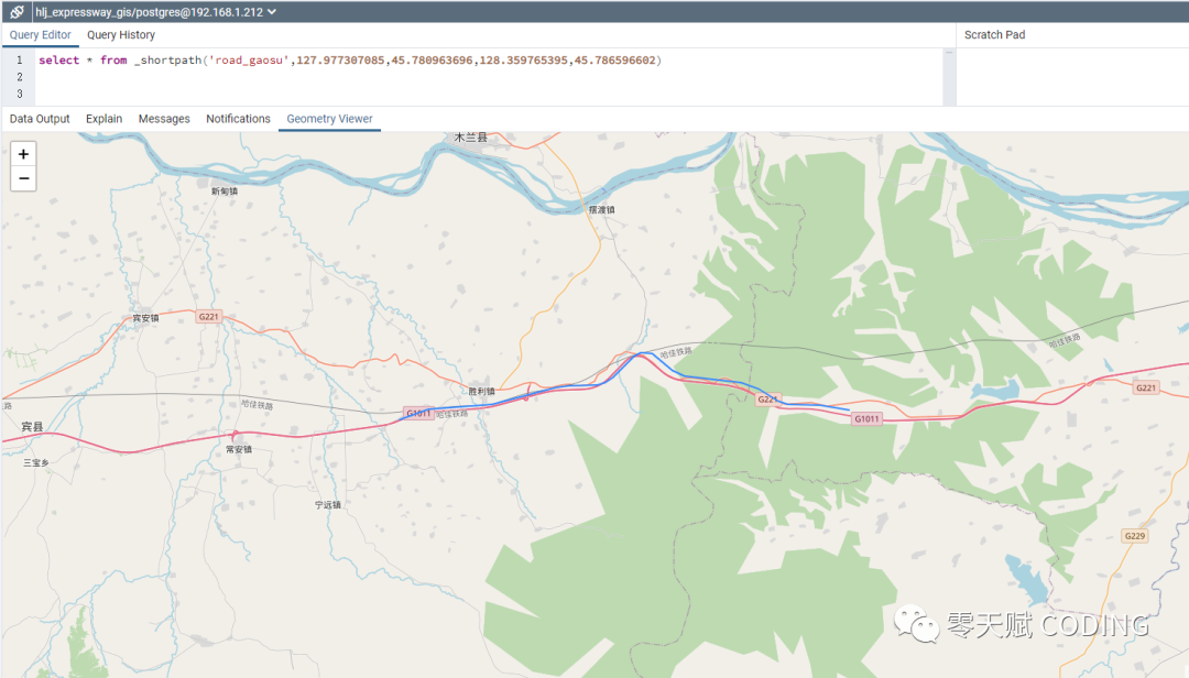
计算最短路径
select * from _myshortpath('hlj_road', x1, y1, x2, y2)
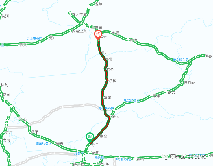
还可以在使用openlayers库展示我们的路径
文章转载自零天赋 CODING,如果涉嫌侵权,请发送邮件至:contact@modb.pro进行举报,并提供相关证据,一经查实,墨天轮将立刻删除相关内容。
